Maps of the Napoleonic Wars
The maps we offer were created by us, based on historical maps — generally published in the nineteenth century — that are now in the public domain. We have incorporated elements such as elevations, a scale in miles and kilometers, and various other useful details relevant to the accompanying text.
They are presented in chronological order.
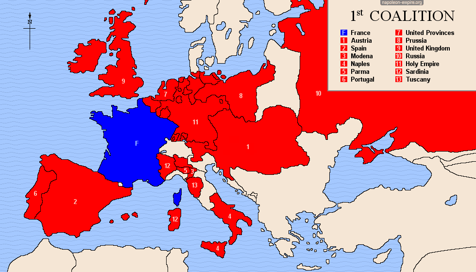
 FIRST COALITION: from 1792 to 1797
It was formed by Prussia and Austria in May 1792, following the declaration of war issued by the French Legislative Assembly against the Emperor Francis II of Germany. England and Holland subsequently joined (February 1793), followed by Spain (March 1793), Portugal, the Kingdom of the Two Sicilies, and the Kingdom of Sardinia.

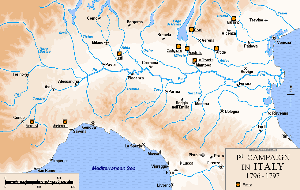
 FIRST CAMPAIGN IN ITALY: from March 1796 to April 1797
For a year, from late March 1796 to April 1797, General Napoleon Bonaparte — leading an army that was, in fact, ill-prepared and poorly equipped — achieved a masterful and unprecedented series of victories against the Sardinians and then the Austrians across a vast territory in northern Italy, spanning the present-day regions of Liguria, Piedmont, Lombardy, Emilia-Romagna, Tuscany, Marche, Veneto, Trentino-Alto Adige, and Friuli.
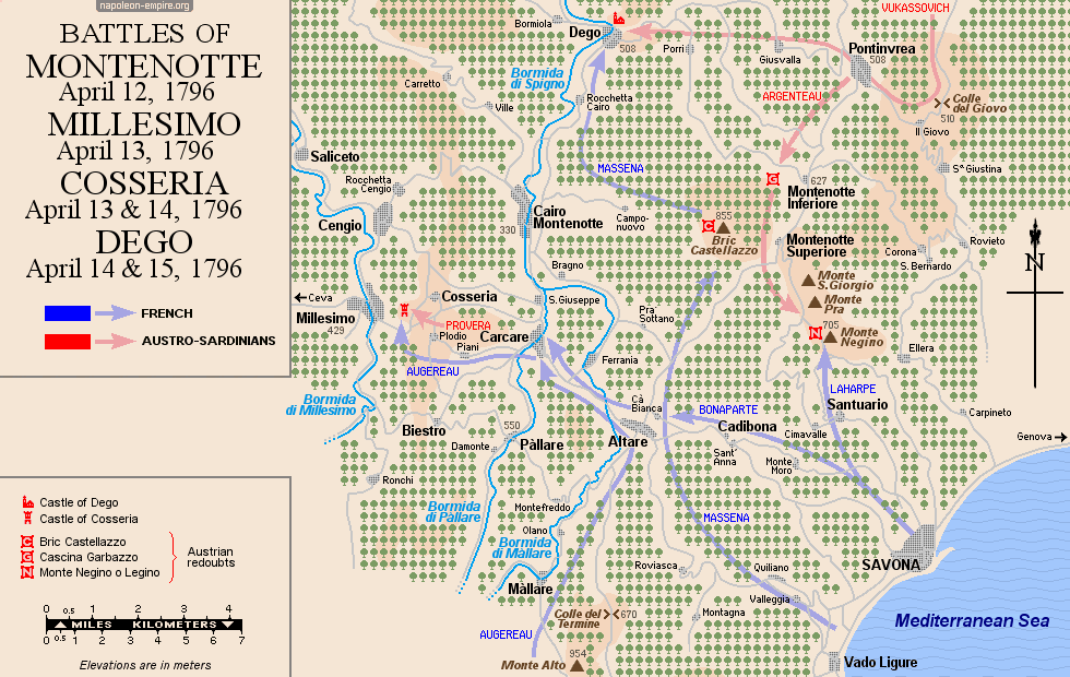
MONTENOTTE, MILLESIMO, COSSERIA and DEGO: Battles from April 12 to 15, 1796
The fighting that launched the first Italian campaign took place northwest of Savona, in Liguria — successively at Montenotte Superiore on April 12, 1796; at Millesimo and Cosseria on April 13; and finally at Dego on April 14 and 15 — across mountainous and heavily wooded terrain.
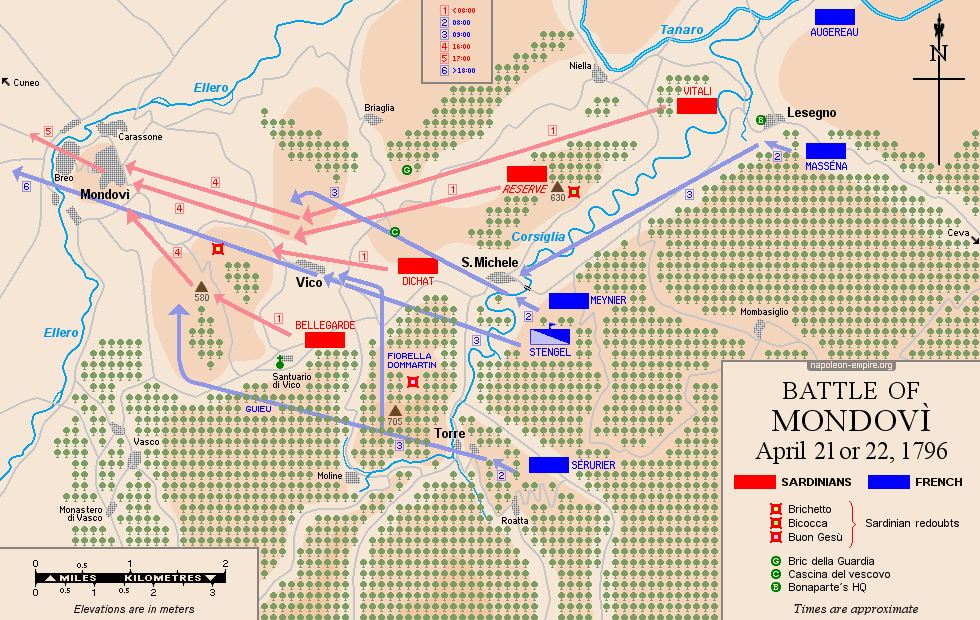
MONDOVI: Battle on April 21, 1796
The Battle of Mondovì began at Ceva and then shifted westward as the Sardinians retreated under French pressure — moving through San Michele Mondovì, then Vicoforte, and finally the hilltop village of Mondovì, located 25 kilometers (15 miles) east of Cuneo. All this took place amidst rugged terrain.
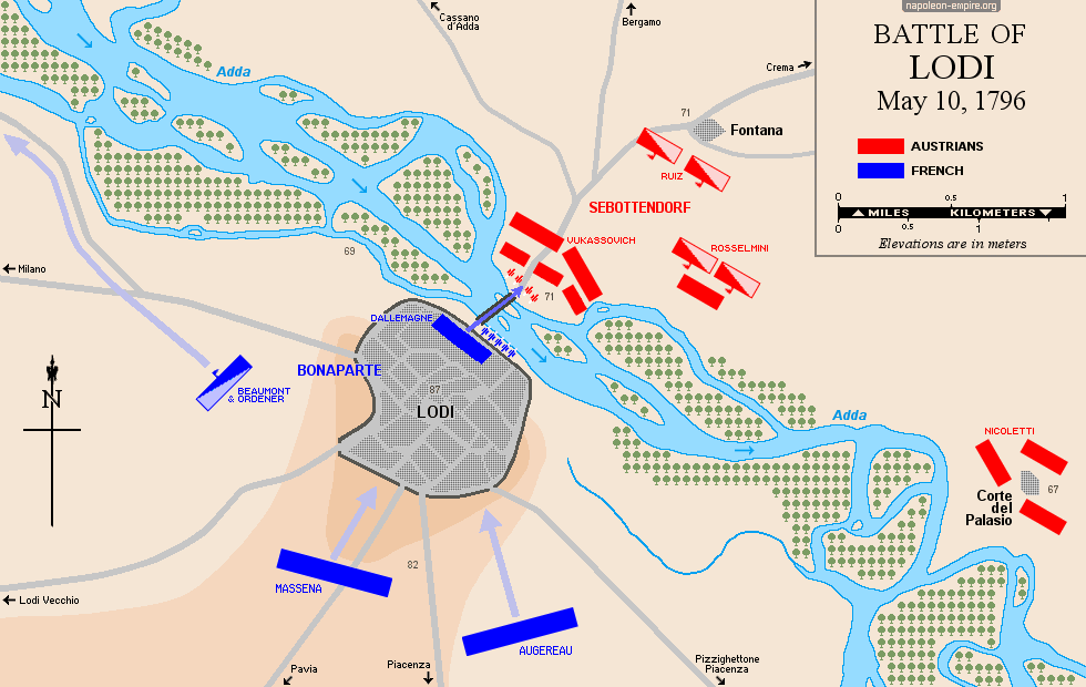
LODI: Battle on May 10, 1796
Napoleon Bonaparte and his chief of staff, General Louis-Alexandre Berthier, were moving northwest from Pizzighettone along the course of the Adda River when they found an intact bridge at Lodi — a town located 31 kilometers (19 miles) southeast of Milan — connecting the town to the left bank of the Adda. The capture of this bridge would prove to be one of the greatest French victories of the First Italian Campaign.
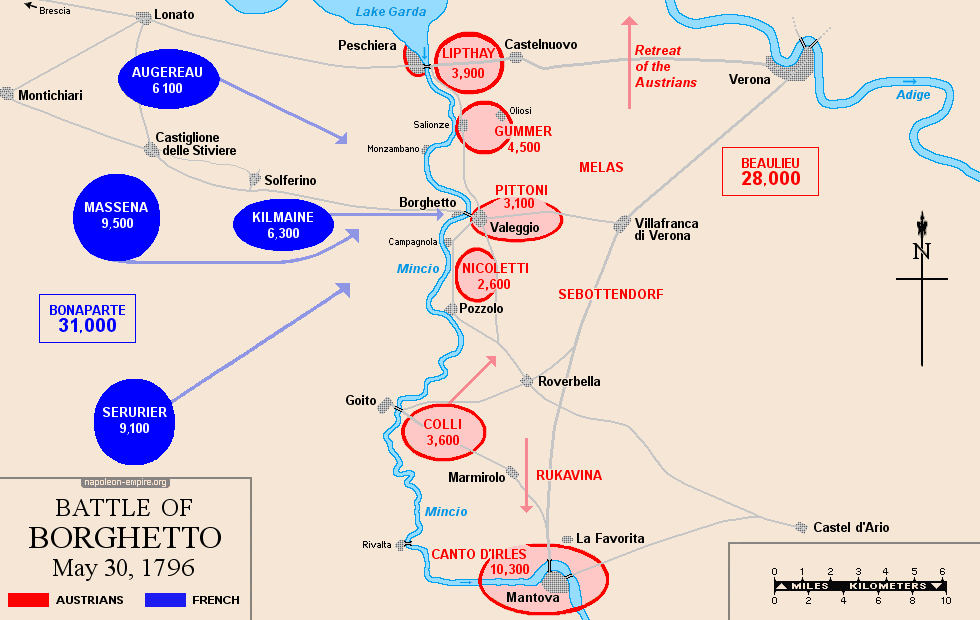
BORGHETTO: Battle on May 30, 1796
The fighting took place at Valeggio-sul-Mincio — a small town twenty-five kilometers (15 miles) southwest of Verona where Bonaparte had established his headquarters and narrowly escaped capture — and subsequently just below the town at Borghetto (literally "Little Village"). There, the Mincio River, widened by several artificial weirs, was spanned by the 14th-century Visconti Bridge [Ponte Visconteo], which measured 650 meters (711 yards) in length and 20 meters (22 yards) in width.
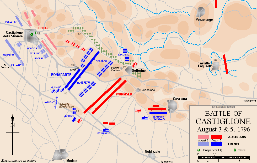
CASTIGLIONE: Battle on August 3 and 5, 1796
Castiglione delle Stiviere is a town located about twelve kilometers (7½ miles) south of Lake Garda, on the road to Mantua [Mantova]. Solferino and San Cassiano lie a few kilometers to the east of Castiglione, Guidizzolo to the southeast, and Medole to the south. It was within this quadrilateral — which includes Monte Medolano (actually a hill) in its western quadrant and consists otherwise of the Medole plain — that the bulk of the fighting took place.
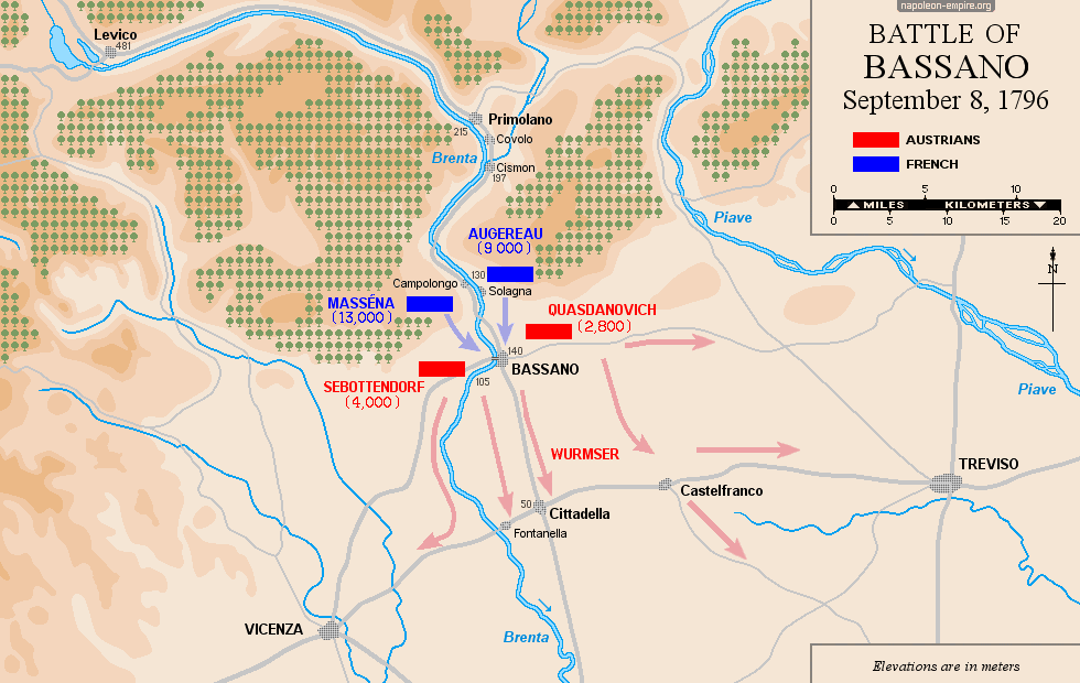
BASSANO: Battle on September 8, 1796
Bassano del Grappa is a city in Veneto, at the foot of the Vicenza Prealps, on the Brenta River.
The divisions of Generals Augereau and Masséna marched rapidly down the river's course from north to south — along the left and right banks, respectively — and broke through the Austrian lines, forcing the enemy to retreat to the southwest, south, and southeast.
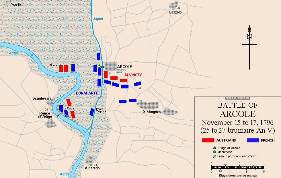
ARCOLE: Battle on November 15 to 17, 1796
The famous Arcole Bridge spans the Alpone torrent, which flows from north to south before emptying into the Adige River, a few kilometers southeast of Ronco all'Adige. The village is situated entirely to the east of the Alpone — that is, on its left bank.
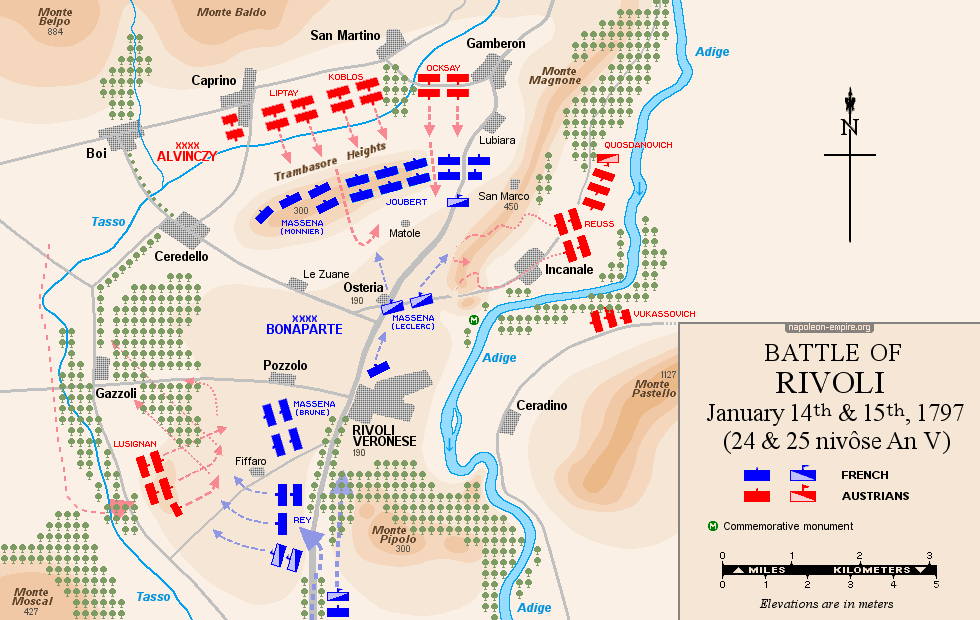
RIVOLI: Battle on January 14 and 15, 1797
Rivoli Veronese is a village in the Veneto region, located east of Lake Garda, 25 kilometers (15 miles) north-northwest of Verona, on the right (western) bank of the Adige River in a mountainous area. The battlefield lies north of the village, extending from the foothills of Monte Baldo to the banks of the Adige; some fighting also took place to the south, on Monte Pipolo.
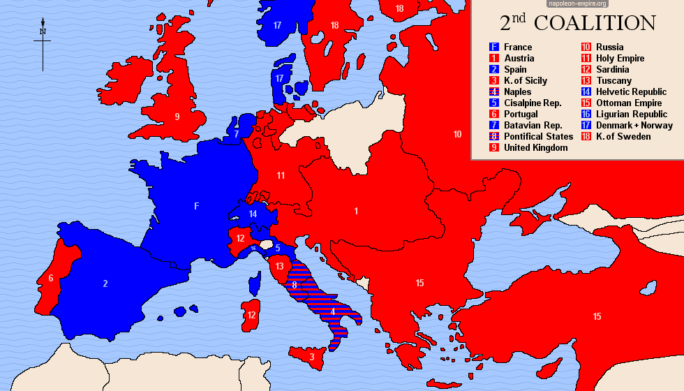
SECOND COALITION: from 1798 to 1802
It was England that took the initiative to assemble this coalition. It succeeded all the more easily because France's conduct since the end of the First Coalition had irritated or alarmed all the major European powers.
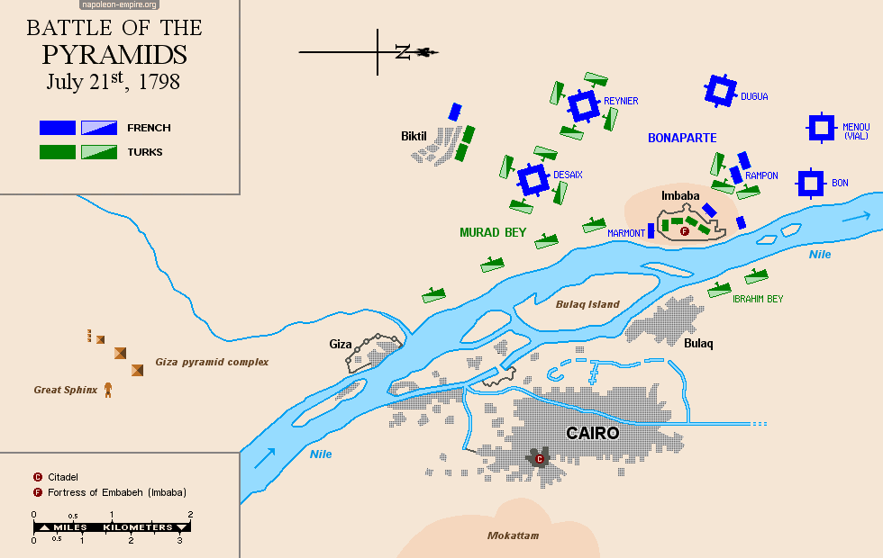
 PYRAMIDS: Battle on July 21, 1798
The battlefield, consisting primarily of sand dunes, is located on the left (west) bank of the Nile River [نهر النيل], 13 kilometers (8 miles) north-northeast of the Giza Pyramids [مجمع أهرامات الجيزة], surrounding Embabeh [إمبابة], a fortified village at the time.
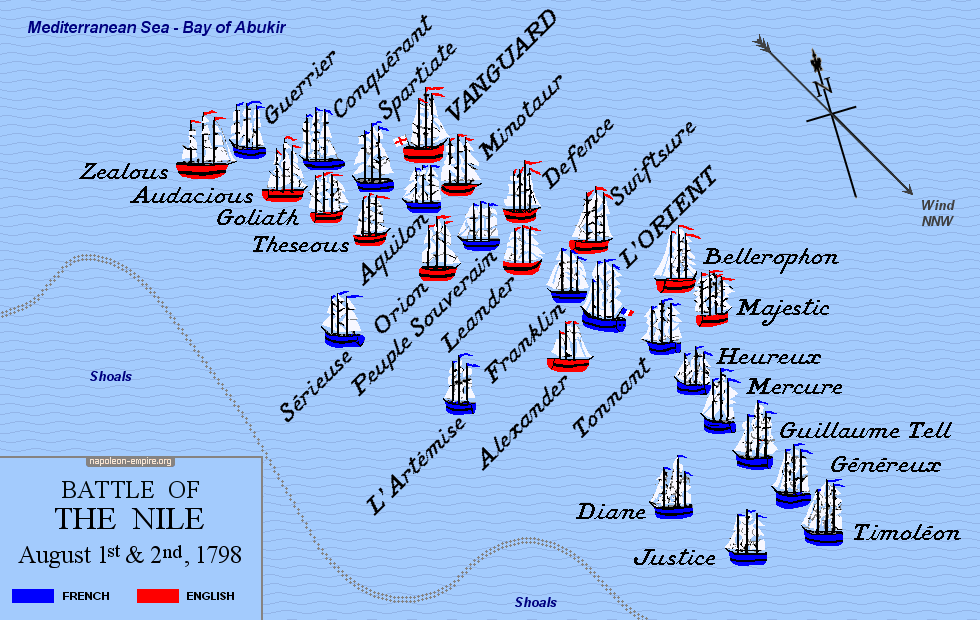
ABOUKIR BAY: Naval battle known as the "Battle of the Nile" on August 1 and 2, 1798
This naval battle took place in the Bay of Aboukir (or Abu Qir), in the Mediterranean Sea off the coast of Egypt, some eighteen nautical miles east-northeast of the Pharos peninsula in Alexandria.
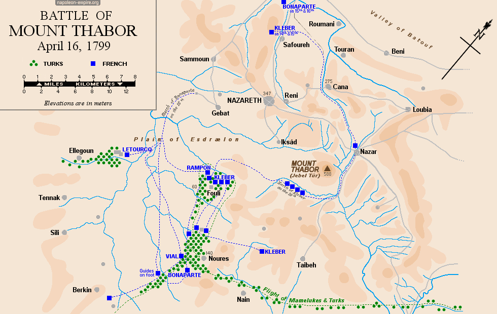
 MOUNT THABOR: Battle on April 16, 1799
This battle — the most significant of the so-called Syrian Campaign — took place on the Plain of Esdraelon [Jezreel Valley], overlooked to the northeast by Mount Tabor or Thabor (rising to 588 meters / 1,886 feet); however, no fighting actually occurred on the mountain's slopes. The routed Mamluks fled eastward, hoping to cross the Jordan River.
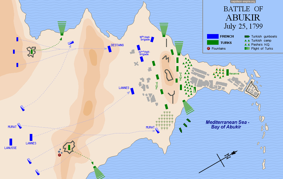
ABUKIR: Battle on July 25, 1799
This battle took place on the Abu Qir (or Aboukir) peninsula, on the Mediterranean coast of Egypt, twenty-three kilometers (14 miles) northeast of Alexandria.
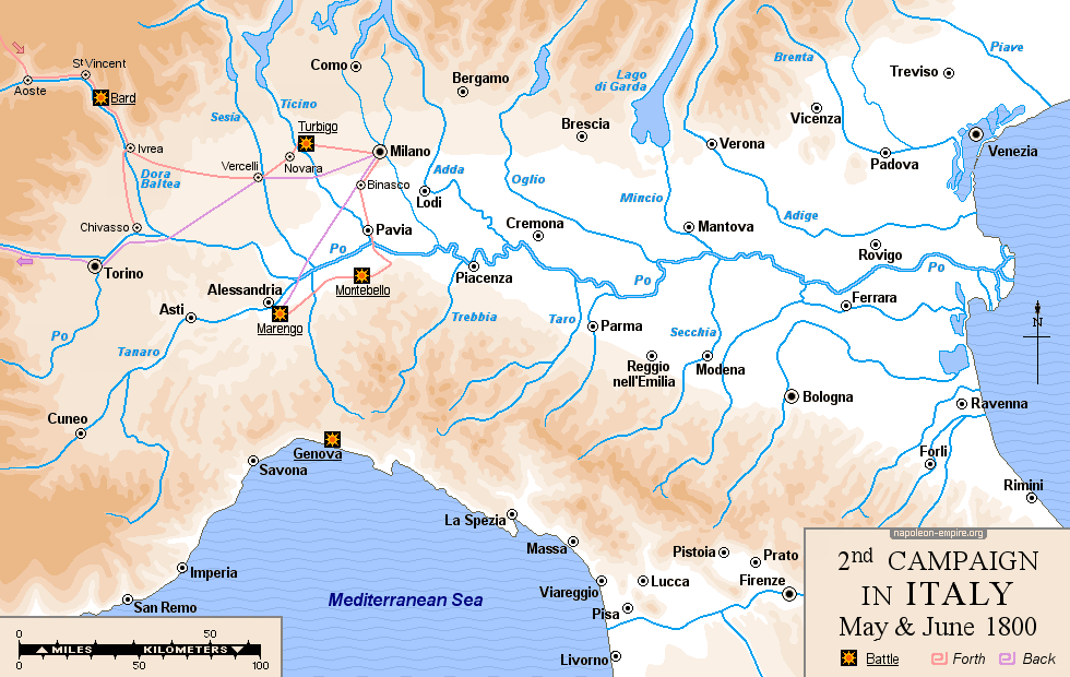
SECOND CAMPAIGN IN ITALY: April to June 1800
While General André Masséna — trapped in the city of Genoa — endured a siege that tied down significant Austrian forces, First Consul Napoleon Bonaparte set out in May and June 1800 to once again confront Austria, which was allied, as part of the Second Coalition, with another continental empire: Russia. Crossing the Swiss Alps and the Aosta Valley, he emerged into Lombardy to defeat the enemy on the upper Po plain.
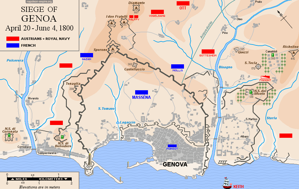
GENOA (GENOVA): Siege from April to June 1800
The city of Genoa, a port on the Ligurian coast of the Mediterranean Sea, is situated between two coastal rivers to the east and west, and is overlooked to the north by a mountainous amphitheater formed by the Ligurian Apennines.
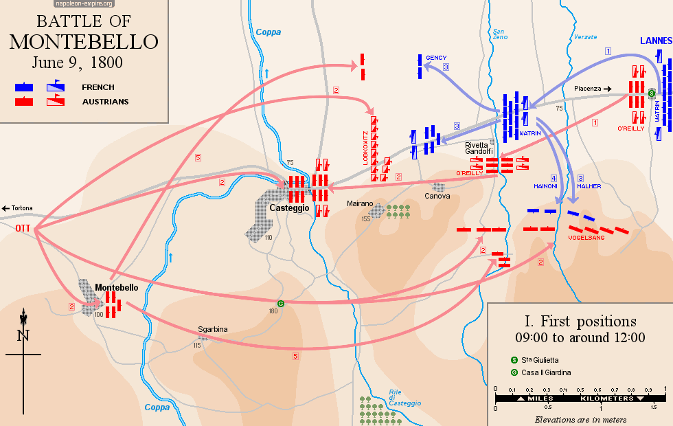
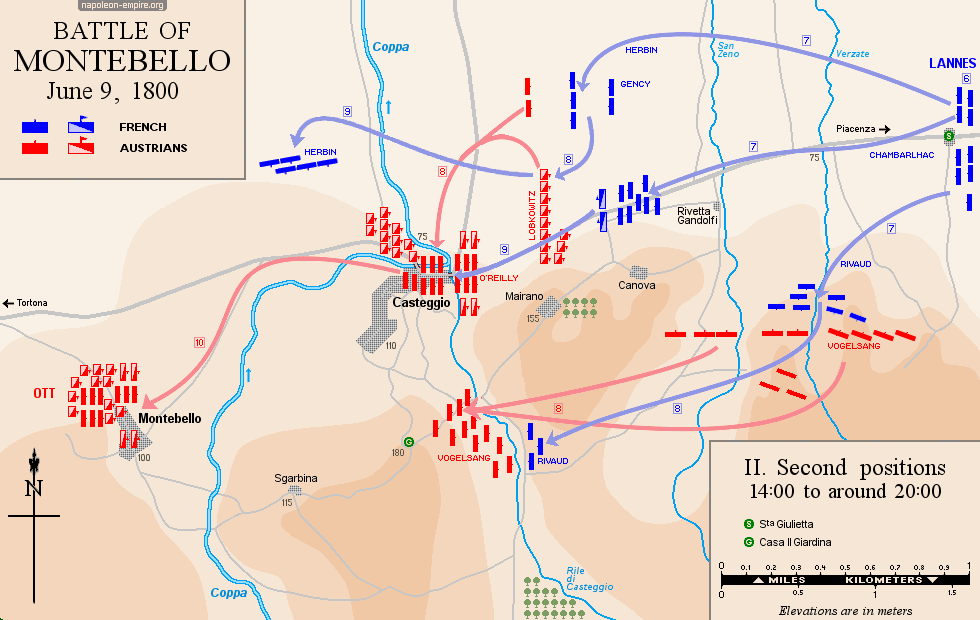
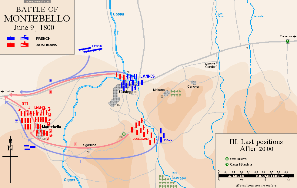
MONTEBELLO: Battle on June 9, 1800
Montebello della Battaglia is a Lombard town on the Po Plain, located thirty kilometers (18½ miles) south of Pavia and sixty kilometers (37 miles) west of Piacenza.
The battle took place on either side of the west-east road leading from Tortona to Piacenza, below the village of Montebello and surrounding the village of Casteggio, located one kilometer to the east. Fighting also raged for control of the heights south of the two villages, initially held by the Austrians. Defeated, the Austrians retreated toward Voghera to the west.
MARENGO: Battle on June 14, 1800
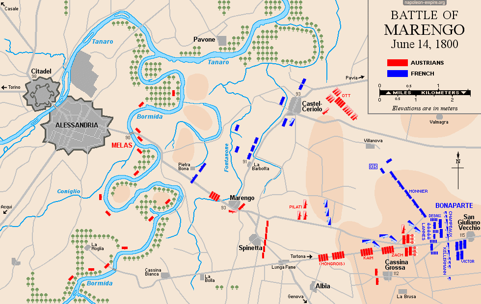
Spinetta Marengo is a commune located three kilometers (1.8 miles) southeast of the fortified city of Alessandria. Flowing between them — towards the northeast — is the Bormida River, a tributary of the Tanaro, which in turn flows into the Po. The road to Tortona runs eastward from Marengo, passing successively through the village of San Giuliano Vecchio and the hamlet of Torre Garofoli. Cascina Grossa lies to the south of this road, and Castelceriolo to the north.
This vast theater of operations is completely flat.
THIRD COALITION: 1805
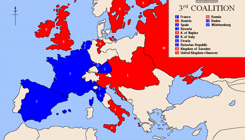
Barely a year after the Treaty of Amiens, relations between France and England were broken off once again. England then set about seeking allies: Russia, Austria, Naples, and Sweden.


 CAMPAIGN IN GERMANY: October to December 1805
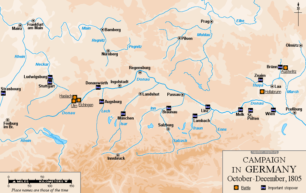
Abandoning his initial plan to invade England, Napoleon raced toward southern Germany, crossing it from west to east at the head of the Grande Armée along the Danube corridor (spanning present-day Germany, Austria, and the Czech Republic) to wage one of his finest military campaigns.
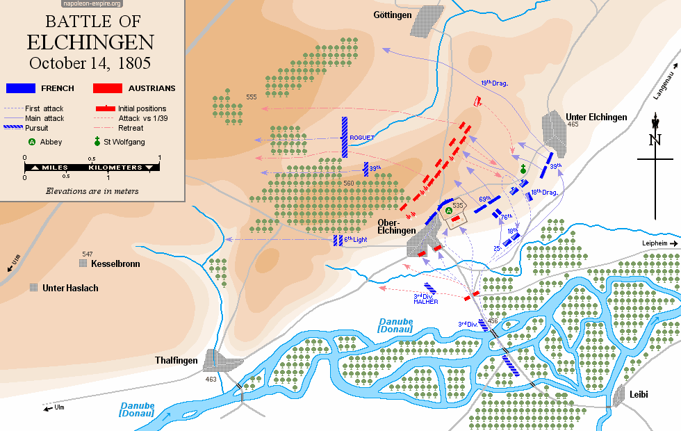
ELCHINGEN: Battle on October 14, 1805
Elchingen [Oberelchingen] is a Bavarian village (bordering Baden-Württemberg) situated 8 kilometers (5 miles) north-northeast of Ulm, on the banks of the Danube. Built on a hillside, it overlooks a meadow — wooded in places and several hundred meters wide — that forms the river's left (northern) bank; a bridge [now made of concrete] connects Elchingen to Nersingen on the opposite bank. Overlooking the village is a Benedictine abbey, followed by a vast plateau extending northward to the small town of Langenau and northwestward toward the villages of Göttingen and Albeck.
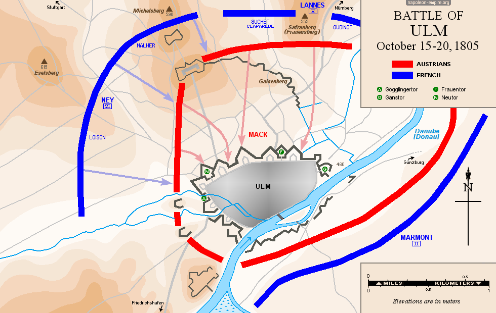
ULM: Siege from October 15 to 20, 1805
It was more of a siege of the city than a battle in the strict sense, even though fierce fighting did take place. The strategic points were located to the north of the city (the Michelsberg and Frauensberg hills).
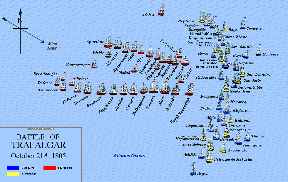
 TRAFALGAR: Battle on October 21, 1805
This naval battle, one of the most decisive of all time, took place in the Atlantic Ocean, approximately 9 nautical miles northwest of Cape Trafalgar, which is located 45 kilometers (28 miles) south-southeast of the Spanish city of Cádiz, in Andalusia.
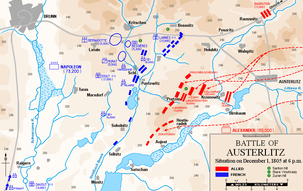
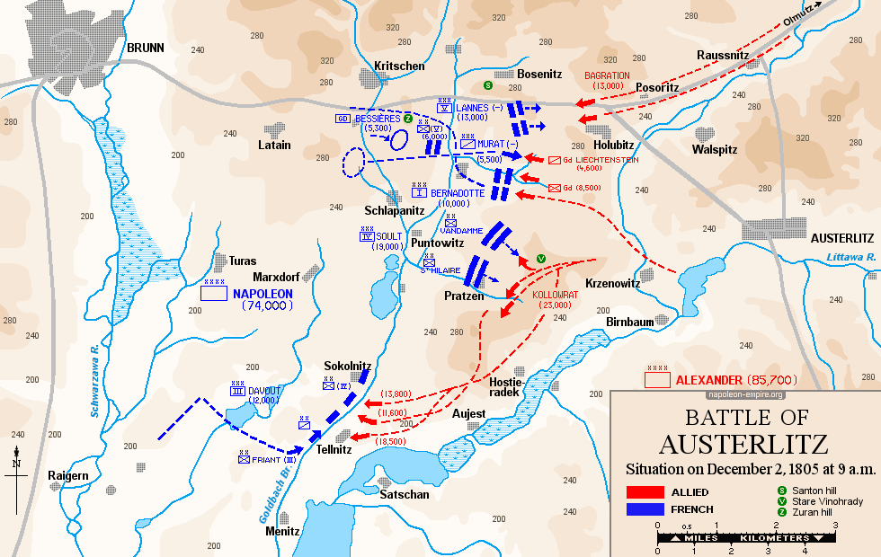
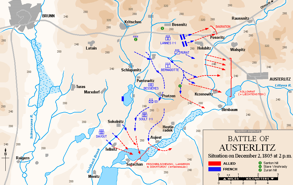
AUSTERLITZ: Battle on December 2, 1805
The Battle of Austerlitz took place over a vast area east of Brünn [Brno] in southern Moravia. The battlefield is roughly shaped like an inverted triangle: its northern base is formed by the Brno–Olomouc road, while its southern tip corresponds to the village of Satschann [Zatcany]. Between the center of the triangle and its eastern edge, the elongated Pratzen [Prace] plateau — oriented southwest to northeast — rises about 80 meters (roughly 260 feet) above the surrounding terrain, which is quite undulating.
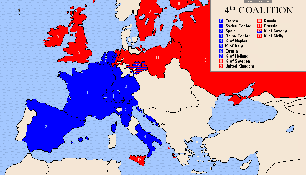
FOURTH COALITION: from 1806 to 1807
This coalition was formed in October 1806 when Prussia — refusing the reorganization of Germany carried out by Napoleon I — joined the countries that had remained at war with France following the Third Coalition.
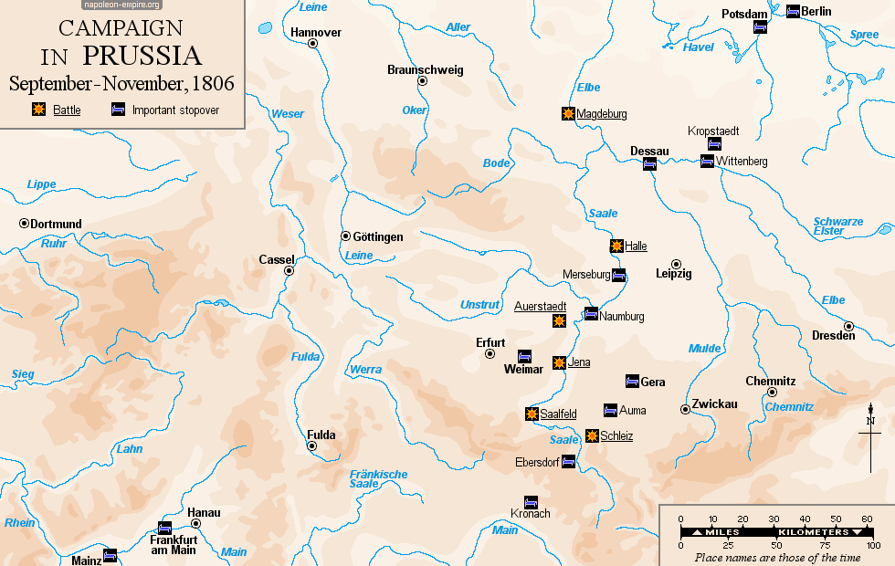
CAMPAIGN IN PRUSSIA: September to November 1806
Napoleon responded swiftly to Prussia's entry into the Fourth Coalition: at the head of the Grande Armée, he advanced northeast from the Main valley along the Saale valley, inflicted a double defeat on the Prussians at Jena and Auerstaedt, and then pressed on to reach and capture Berlin in less than two weeks.
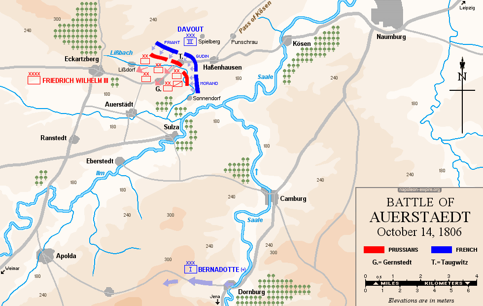
AUERSTAEDT: Battle on October 14, 1806
Auerstaedt is a village located some thirty kilometers (18 miles) north of Jena — a German city in northern Thuringia where another Napoleonic victory took place on the same day. The battlefield, situated to the north and east of the village, is gently rolling and crossed by a stream, the Lissbach.
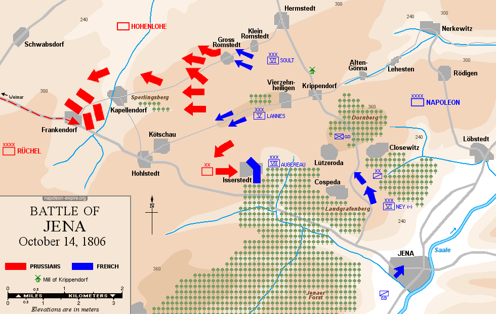
JENA: Battle on October 14, 1806
Jena is a city in northern Thuringia, located in the Saale Valley. The battlefield, situated northwest of the city, is hilly — featuring the Dornberg hills in the center, the Sperlingsberg to the west, and the Landgrafenberg to the south — and heavily wooded south of the Isserstedt–Lützeroda–Closewitz line.
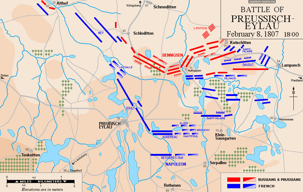
 EYLAU: Battle on February 8, 1807
The Battle of Eylau took place in East Prussia [Ostpreußen], within a radius of about ten kilometers (6 miles) around the town of Preußisch Eylau.

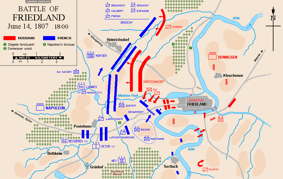
FRIEDLAND: Battle on June 14, 1807
Friedland was a small town in East Prussia, about thirty kilometers (18 miles) east of Preussisch Eylau, on the banks of the Alle River.
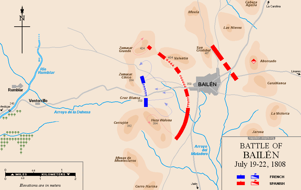
BAILÉN: Battle from July 19 to 22, 1808
Bailén (or Baylén) is an Andalusian town located in the modern-day province of Jaén, about forty kilometers (25 miles) north of the provincial capital.
The terrain of the battlefield is moderately uneven but, above all, very arid. Today, olive cultivation is omnipresent — and far more intensive than it was at the time.
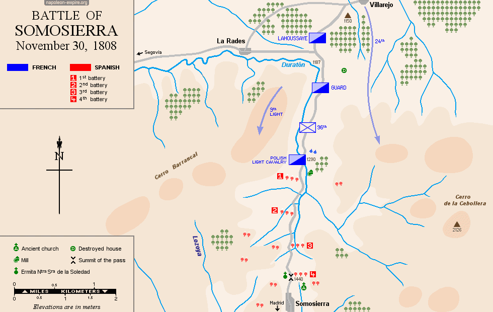
SOMOSIERRA: Battle on November 30, 1808
The Somosierra Pass, reaching an elevation of 1,438 meters (4,718 feet), is one of the few routes providing access to Madrid from the north (Burgos) across the Sierra de Guadarrama. The road leading to it, running north-south, was moderately winding at the time.
The battlefield consists of the road itself and its verges — averaging about thirty meters (100 feet or so) in total width — spanning the final two kilometers of the ascent. To the right (west), lying slightly lower, runs a stream named El Duratón; to the left (east) rise the slopes of Peña Cebollera.
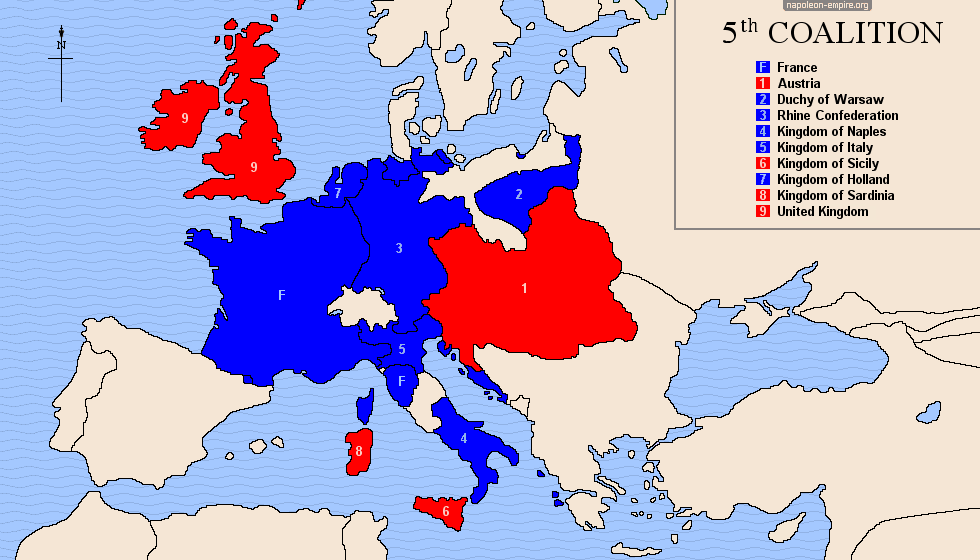
FIFTH COALITION: 1809
Napoleon I's initial setbacks in Spain led Austria to yield to British entreaties and reignite the war (April 1809).
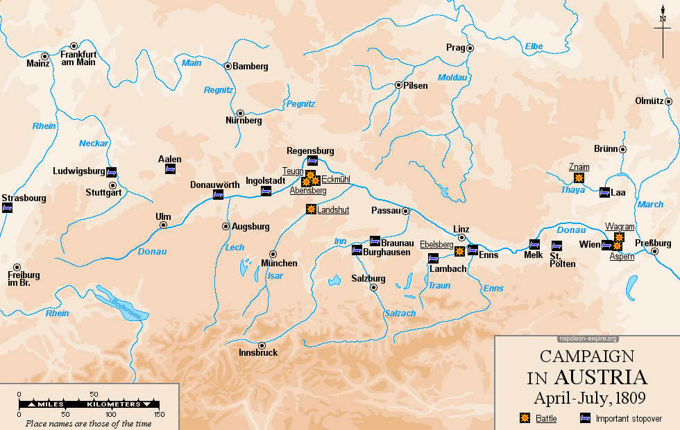
CAMPAIGN IN GERMANY AND AUSTRIA: April to July 1809
After the Austrians crossed the Inn River to enter the Kingdom of Bavaria, Napoleon once again took command of the Grande Armée and followed a route closely resembling that of 1805 — along the Danube corridor — to reach Vienna and southern Moravia.
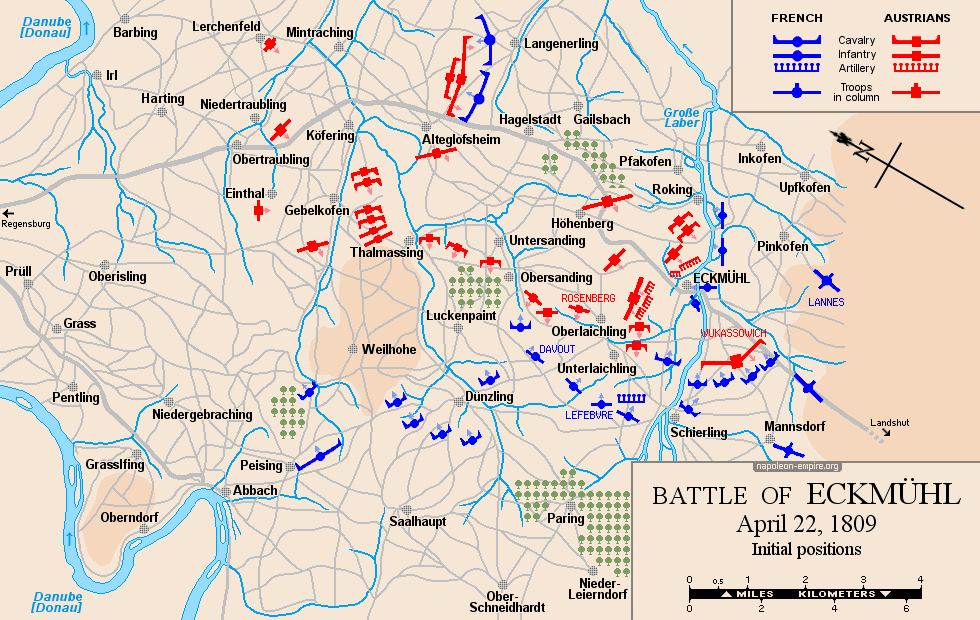
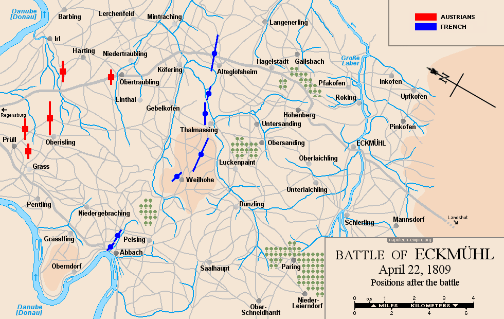
ECKMÜHL: Battle on April 22, 1809
The village of Eggmühl [modern spelling] is located twenty-six kilometers (16 miles) south-southeast of Regensburg, in Bavaria. The fighting took place within an area spanning four to five kilometers (approximately 3 miles) around Eckmühl, and subsequently — during the Austrian retreat — along the road to Regensburg and on either side of it, extending as far as Alteglofsheim and Köfering.
The terrain, which is heavily undulating and wooded, is traversed by the Grosse Laber river.
ASPERN-ESSLING: Battle on May 21 and 22, 1809
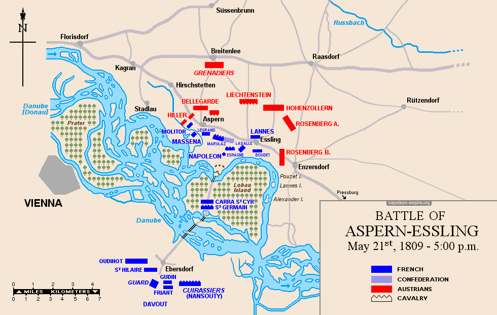
The Battle of Aspern-Essling is known as the Battle of Aspern to German speakers and the Battle of Essling to French speakers; the fierce and bloody clashes indeed took place in and around these two villages — located north of the Danube — as well as at Gross-Enzersdorf, slightly further east.
Lobau Island, situated further south between the Danube and one of its branches, measures four kilometers by three (2½ by 2 miles) and consists of woodland and marshland, all crisscrossed by roads and dirt tracks.
WAGRAM: Battle on July 5 and 6, 1809
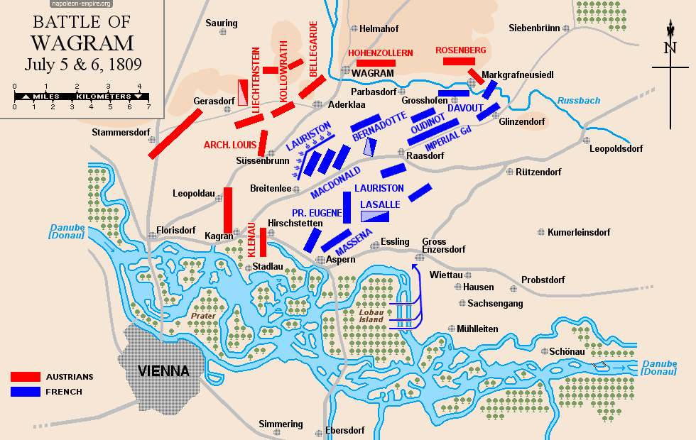
The battlefield lies immediately north of the Aspern-Essling site, on the Marchfeld plain. It is bounded to the west by the heights of Gerasdorf; to the north by a stream, the Russbach — whose bed forms a depression one to two meters deep and whose north bank, beyond a narrow terrace, rises into an escarpment several meters high: the Wagram plateau; and to the east by the village of Glinzendorf.
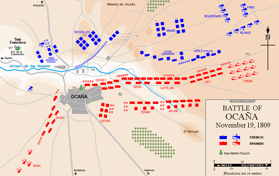
OCAÑA: Battle on November 19, 1809
Ocaña is a large Castilian town located 65 kilometers (40 miles) south of Madrid and 50 kilometers (31 miles) east of Toledo; at the time, it likely comprised some 1,000 houses and 5,000 inhabitants.
The battlefield, arid and undulating (particularly to the northeast, where the Ocaña Plateau lies), is crossed from east to west by a stream known as the Arroyo de los Yesares.
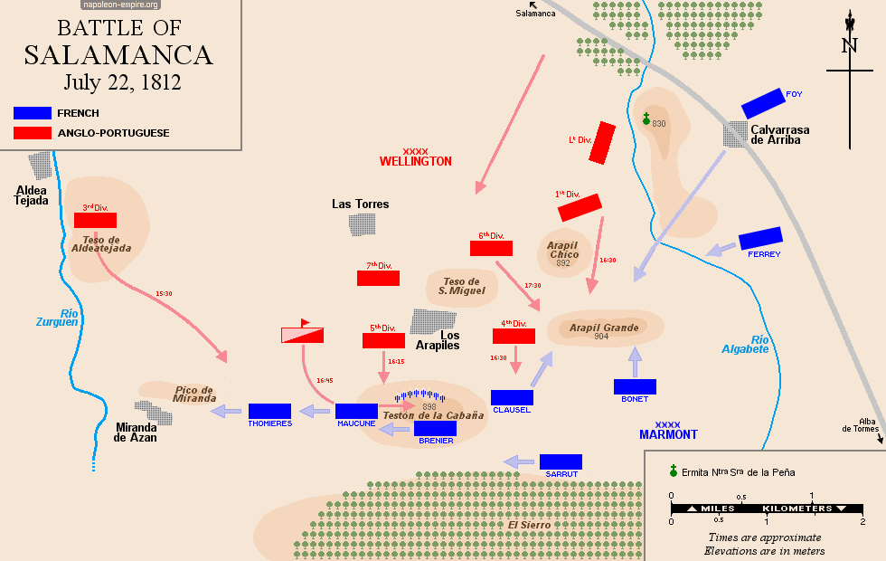
SALAMANCA: Battle on July 22, 1812
The Battle of Salamanca (known as the Battle of the Arapiles to French speakers) took place a few kilometers southeast of that city (the capital of the province of the same name, located today in the southwest of the Castile and León region).

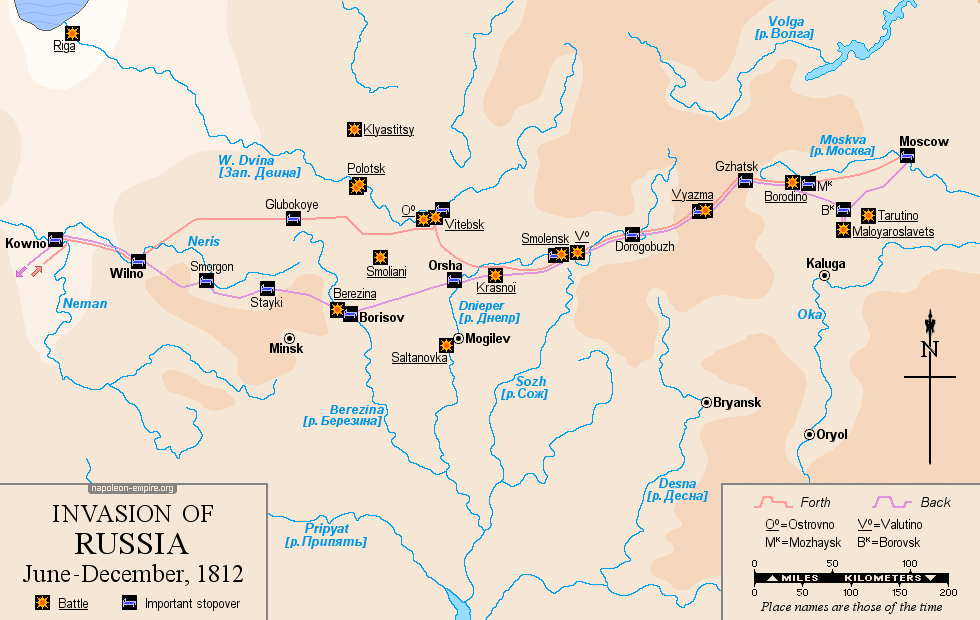
 INVASION OF RUSSIA: June to December, 1812
Believing that Russia's failure to honor the Treaty of Tilsit justified military intervention, Napoleon launched the Grande Armée across the Niemen River, heading east toward Smolensk. Russian strategy then drew him onward to Moscow — 995 kilometers (618 miles) from his starting point — a fatal error. The retreat retraced the same path as far as Smolensk, then continued along a route further south than the one taken on the advance; this required crossing the Berezina River, a name that still chills the blood to this day.
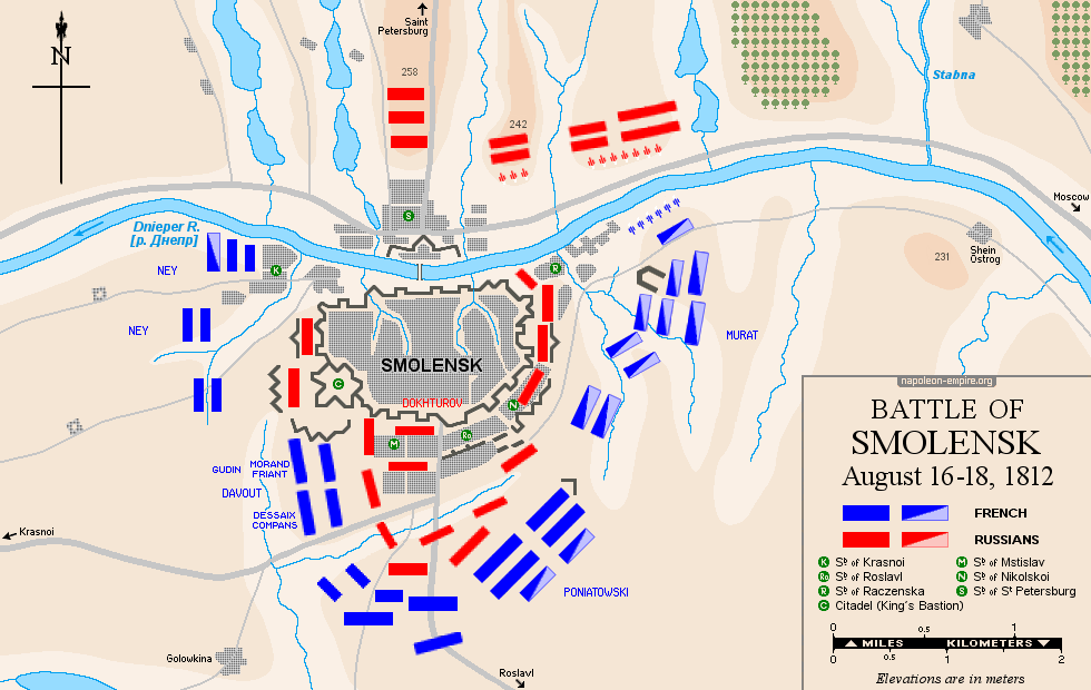
SMOLENSK: Battle from August 16 to 18, 1812
This first major clash of the French invasion of Russia took place around and in the fortified town of Smolensk [Смоленск], which stands on the left (south) bank of the Dnieper River [Дняпро].
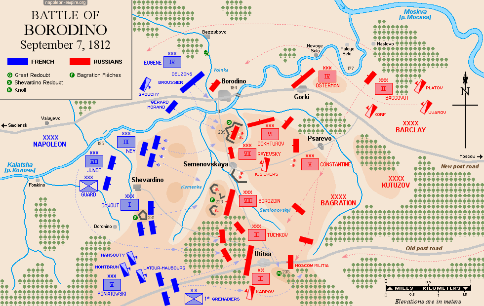
BORODINO: Battle on September 7, 1812
The largest battle of the Russian Campaign took place south of the small village of Borodino [Бородино], 125 kilometers (78 miles) west of Moscow. The Moskva River [Москва-река] flows six kilometers (4 miles) to the northeast and saw no fighting. However, the French named the battle after the river (Bataille de la Moskowa) — likely because it flows downstream through Moscow, from which it takes its Russian name.
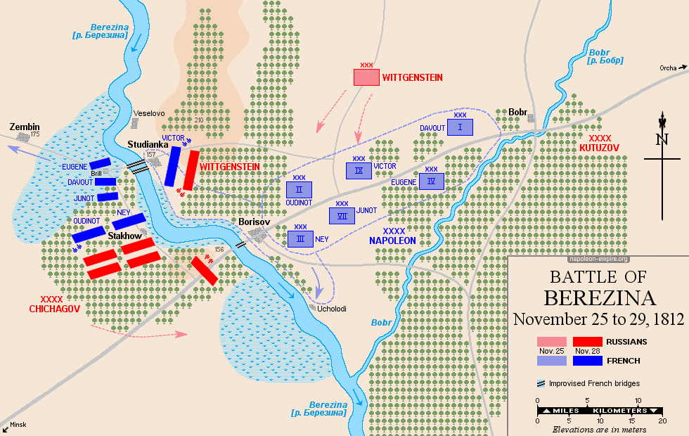
BEREZINA: Battle from November 26 to 29, 1812
This battle, which almost single-handedly symbolizes the disastrous retreat from Russia, was nevertheless a tactical victory for the French. It involved crossing the Berezina River [Бярэзіна] upstream from the town of Borisov, using bridges built by army engineers under appalling conditions. This enabled the remnants of the Grande Armée to continue their retreat westward..
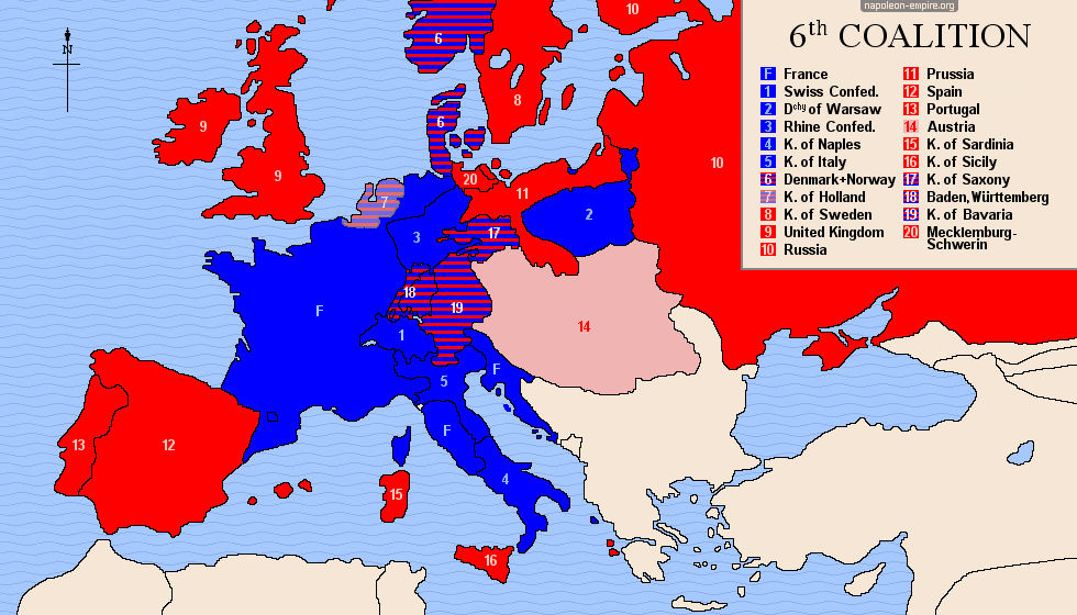
SIXTH COALITION: 1813-1814
The Austrians joined the alliance during the summer. Bavaria switched sides in October, soon followed — as the French situation became desperate — by Baden, Württemberg, and Saxony. The Netherlands, having only just been restored as a sovereign principality in November 1813, also joined the coalition. Finally, Denmark was compelled to join in early 1814 after being defeated by the Swedes.
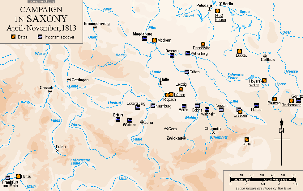
CAMPAIGN IN SAXONY: April to November, 1813
In response to the formation of the Sixth Coalition, Napoleon I personally took command of the forces at his disposal in Germany and moved to confront the Allies along the valleys of the Saale, Elbe, Spree, and Neisse — and even further east — before eventually being forced to retreat toward Hesse and then France.
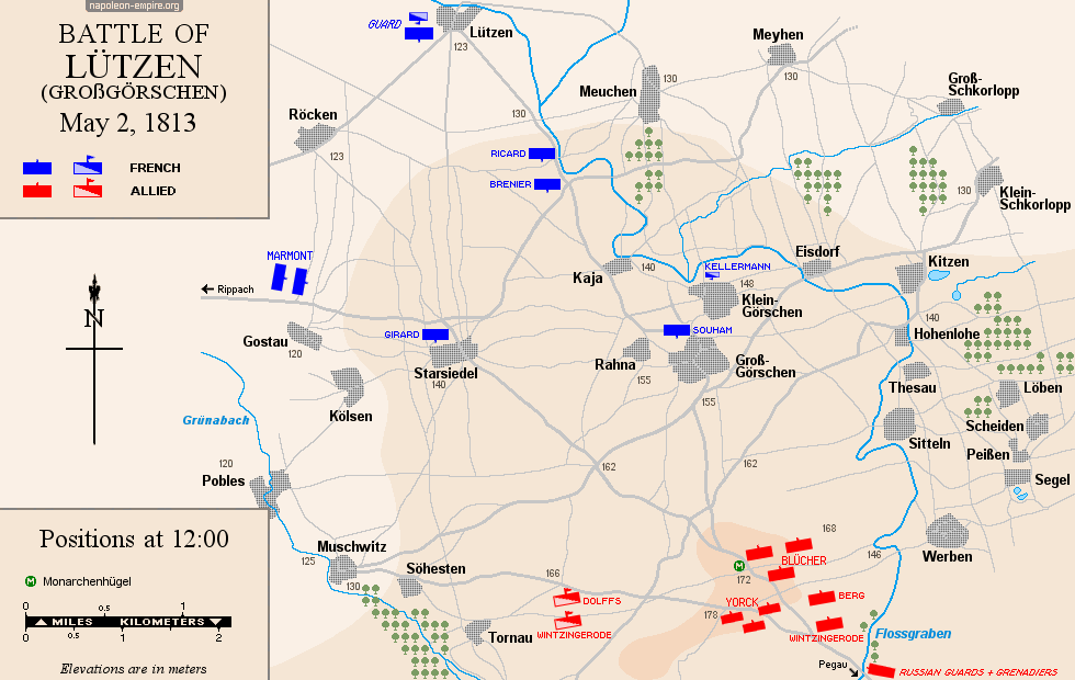
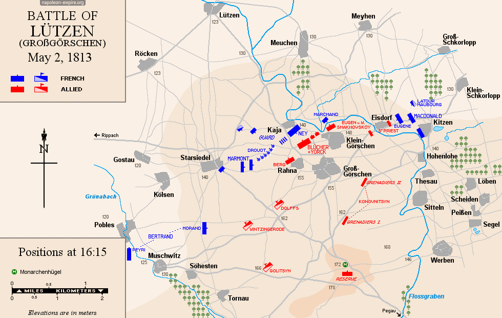
LÜTZEN: Battle on May 2, 1813
Lützen, located 20 kilometers (12½ miles) west-southwest of Leipzig, gave its name to this battle (except in Germany, where it is known as the Battle of Großgörschen), even though no fighting actually took place there — much like at Austerlitz, Jena, or Waterloo. The battlefield, situated south of Lützen, is rolling and rural.
VITORIA: Battle on June 21, 1813
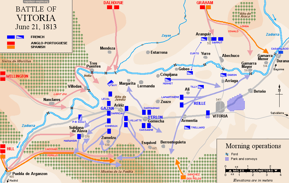
The city of Vitoria [Gasteiz], in the Spanish Basque Country, lies at the crossroads of several strategic routes within this mountainous region: southwest towards Burgos and Madrid, northwest towards Bilbao [Bilbo], northeast towards San Sebastián [Donostia], and east towards Pamplona [Pamplona] — the latter two leading towards France.
The battlefield is a basin surrounded by mountains, measuring twenty by ten kilometers (12½ by 6 miles). Fighting began to the southwest and west of the city, on both sides of the Zadorra River, a tributary of the Ebro [Ebro]. As the French retreated, the fighting continued to the north of the city and within the city itself. The French troops’ rout unfolded in disarray towards Pamplona, to the east.
DRESDEN: Battle on August 26 and 27, 1813
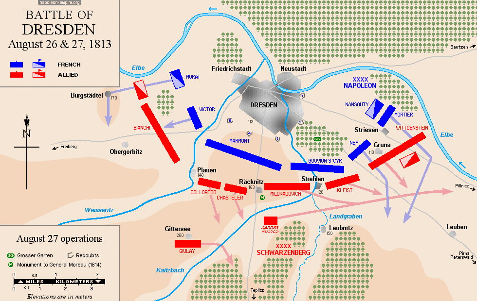
Dresden is a city in Saxony, located on the Elbe River, 190 kilometers (118 miles) south of Berlin. Largely destroyed by the Royal Air Force in February 1945, the historic center has since undergone a spectacular reconstruction, particularly following German reunification. At the time, the battlefield — extending to the east, south, and west of the city — consisted of numerous small villages.
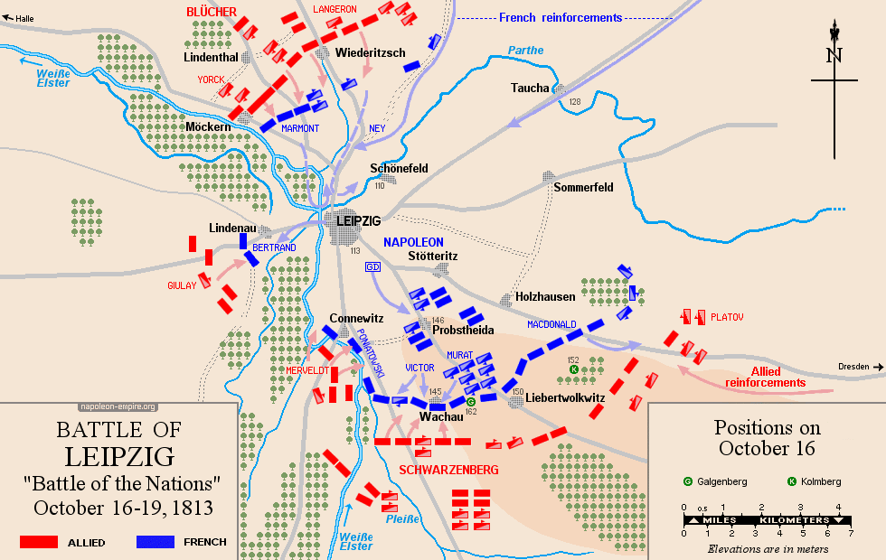
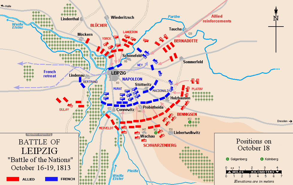
LEIPZIG: Battle known as "Battle of the Nations" from October 16 to 19, 1813
Leipzig is a city in Saxony that had a population of approximately 32,000 during the Napoleonic Wars. The battlefield, vast and virtually flat, surrounds the city (except to the west) and, at the time, was dotted with numerous villages.
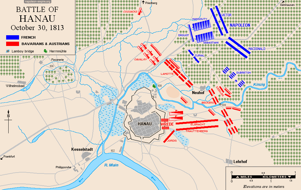
HANAU: Battle on October 30, 1813
Hanau is a small town in Hesse located some thirty kilometers (18 miles) east of Frankfurt am Main, within a loop of the Kinzig River, which joins the Main a few kilometers further south. The battlefield, situated to the northeast and east of Hanau, is heavily wooded (notably the Lamboy Forest).
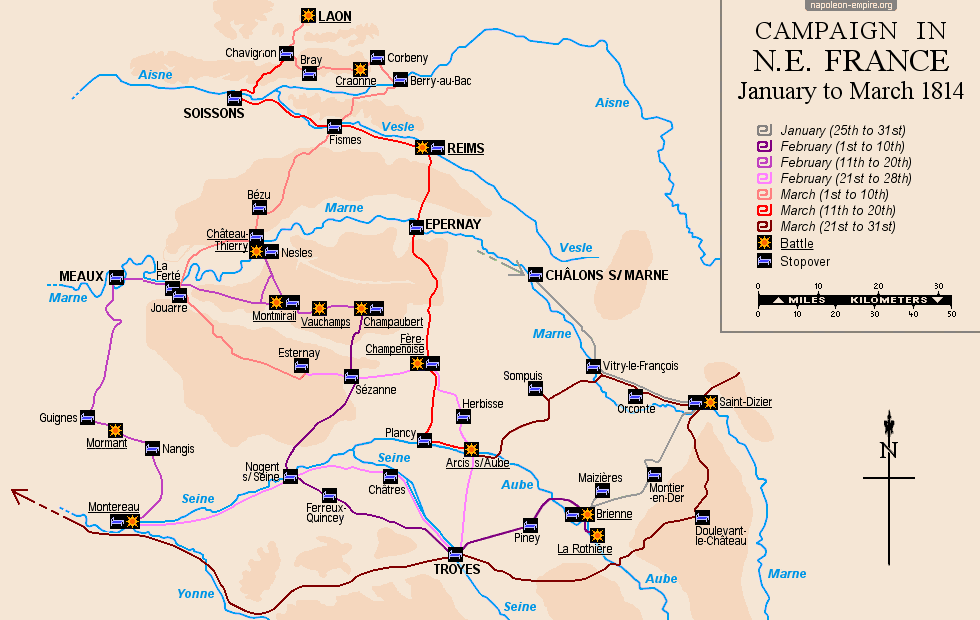
 CAMPAIGN IN NORTHEAST FRANCE: January to March 1814
In just over two months — from January 25 to March 31, 1814 — Napoléon I held his own against the allied Russian-Prussian and Austrian armies, executing a whirlwind campaign across the departments of Marne, Aube, Aisne, and Seine-et-Marne in northeastern France.
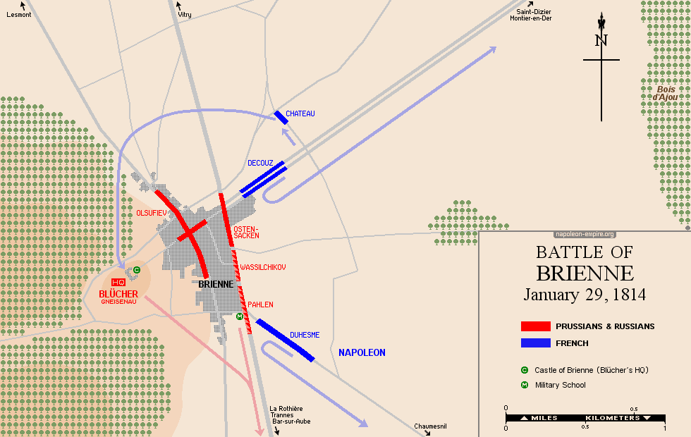
BRIENNE: Battle on January 29, 1814
The town of Brienne-le-Château, in Champagne, is located 37 kilometers (23 miles) east-northeast of Troyes. The battle took place at the château and its terraces overlooking the town, as well as in the town's streets; fighting also occurred northeast of the town, in the Maizières woods, and to the north, at Rances. The battlefield covers a very small area.
CHAMPAUBERT: Battle on February 10, 1814
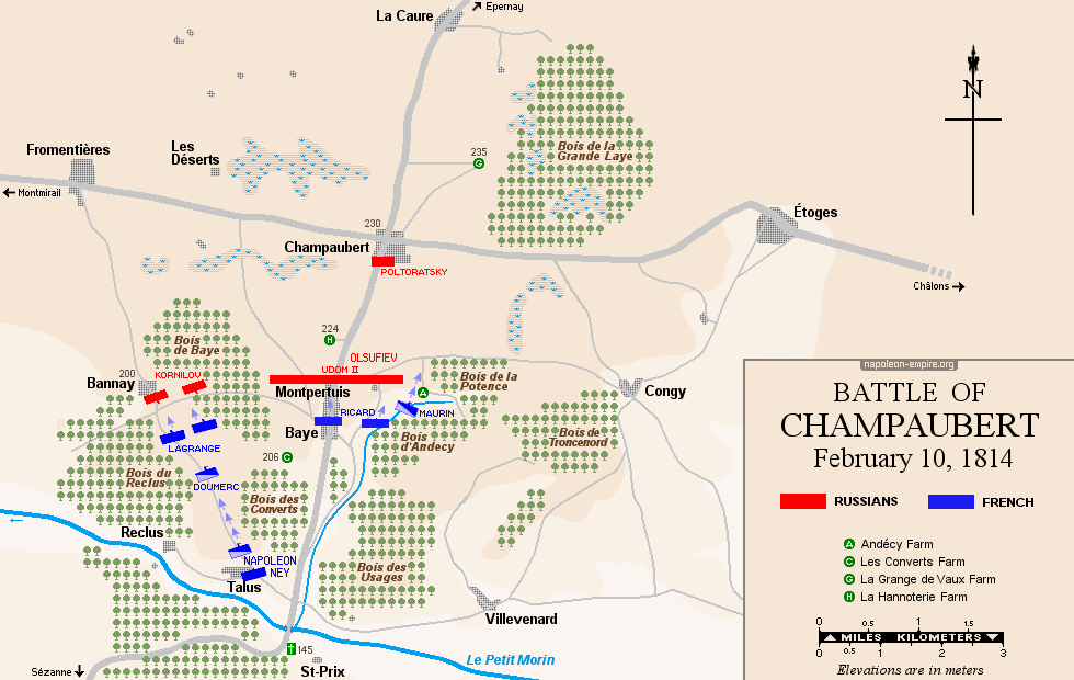
In 1814, the small village of Champaubert was a key strategic crossroads, situated where the east-west Châlons-Montmirail-Meaux-Paris road met the north-south Reims-Epernay-Sézanne-Troyes road.
The terrain where the battle took place — moderately undulating and wooded in places — lies on either side of these two routes, within a six-kilometer (4-mile) radius of Champaubert: extending west to Fromentières, north to La Caure, east to Etoges, south to the Petit-Morin stream (passing through Baye), and southwest to Bannay and its surrounding area.
MONTMIRAIL-MARCHAIS: Battle on February 11, 1814
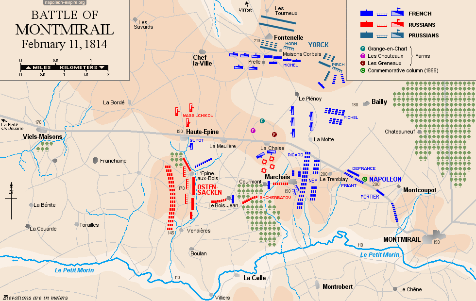
The town of Montmirail is situated at the intersection of the northeast-southwest road connecting Château-Thierry to Troyes and the east-west road leading from Châlons-en-Champagne to Paris. The fighting took place on either side of the latter — west of Montmirail — particularly within the territory of the commune of Marchais-en-Brie.
VAUCHAMPS: Battle on February 14, 1814
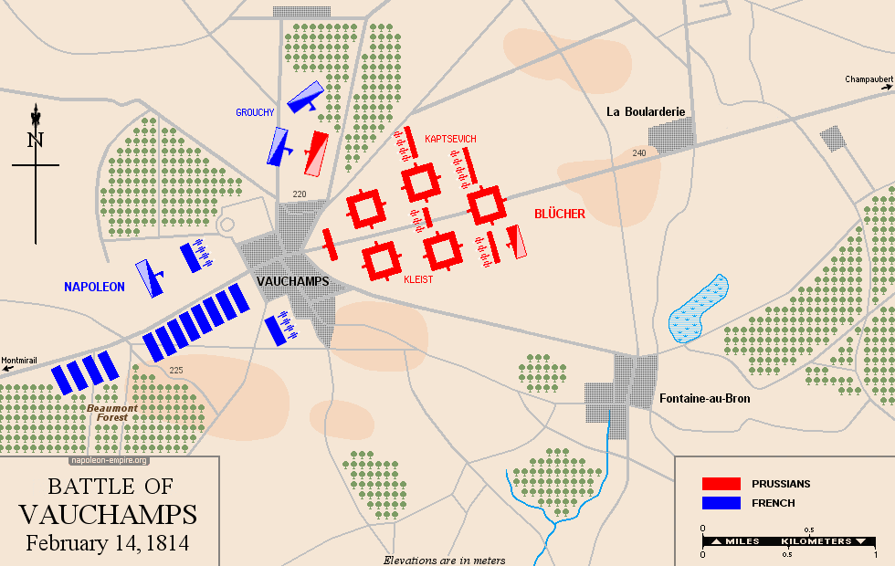
The village of Vauchamps is located east of Montmirail, on the road leading to Champaubert, Etoges, and Châlons-en-Champagne.
The fighting took place in the very streets of Vauchamps, then in the woods of L'Echelle and Hautefeuille — north of the latter — and finally at Serrechamps, Janvilliers, and Fromentières, to the east-northeast.
The French pursuit of the Prussians continued as far as Champaubert and Etoges, further east still.
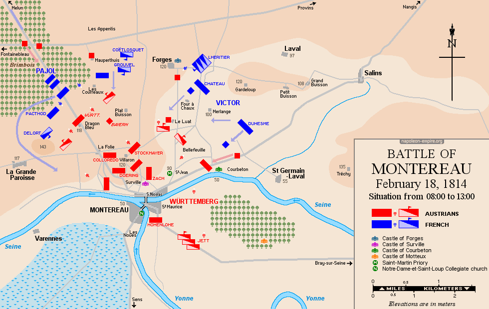
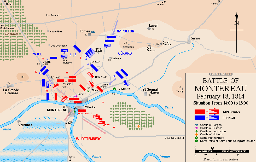
MONTEREAU: Battle on February 18, 1814
The preliminary fighting took place on the Brie plain, in the vicinity of Mormant and Grandpuits, and then — moving southward — at Valjouan, Villeneuve-le-Comte [now Villeneuve-les-Bordes], and Orvilliers.
The decisive battle engulfed Montereau [now Montereau-Fault-Yonne] — a town situated at the confluence of the Yonne and the Seine — and the suburbs overlooking it to the north: Surville and Villaron.
CRAONNE: Battle on March 7, 1814
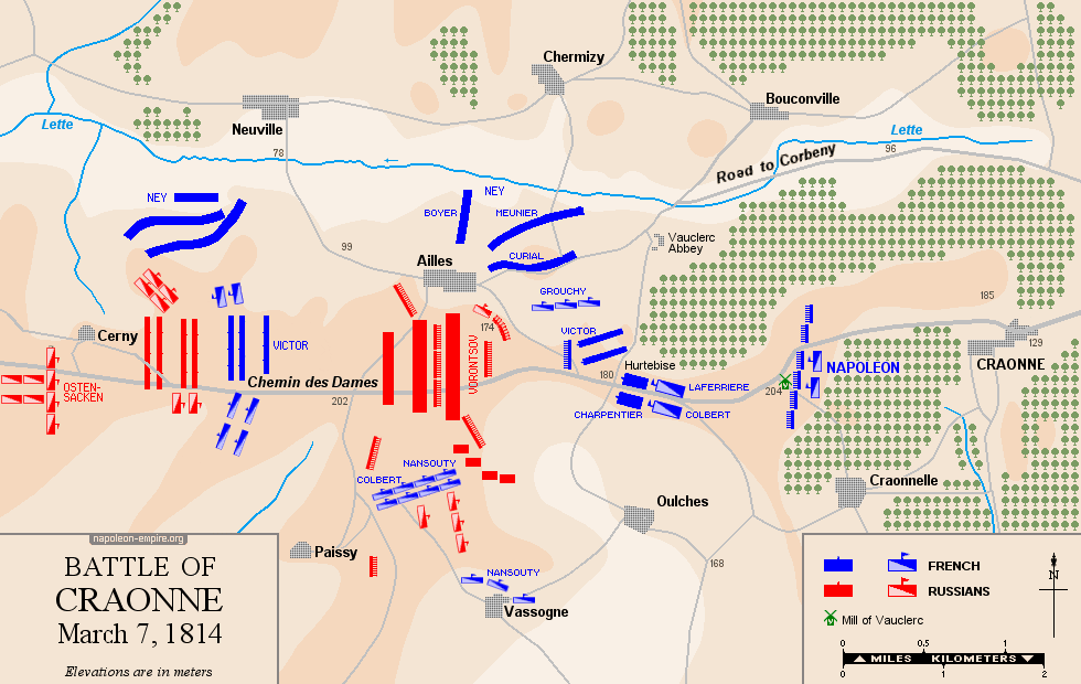
This battle took place on the Craonne plateau, some twenty kilometers (12½ miles) south of Laon, on either side of the Chemin des Dames — specifically around Vauclair Abbey and the Heurtebise farm. A century later, even deadlier fighting occurred in the same locations; the villages of Craonne and Ailles were wiped off the map — due to "advances" in artillery — and never rebuilt.
LAON: Battle on March 9 and 10, 1814
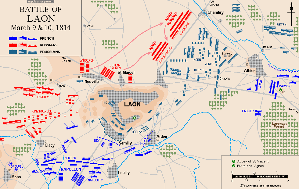
The fortified city of Laon sits atop an elongated ridge running east-west, towering some hundred meters above the Picardy plain to the north and a more undulating landscape to the south. At the time, it was held by Prussian and Russian forces under the command of Field Marshal Blücher. Fighting took place on the 9th at Semilly and Clacy, southwest of the city; at Leuilly, to the south; and on the Ardon slope at the foot of the ridge.
That evening, Marmont drove the Prussians out of Athies, east of Laon, but during the night they caught the French off guard in a surprise attack — the famous "Ura" — chasing them across the surrounding plains and woods and driving them southeast as far as Festieux. On the 10th, fierce clashes between the opposing forces erupted once again at Clacy and Ardon.
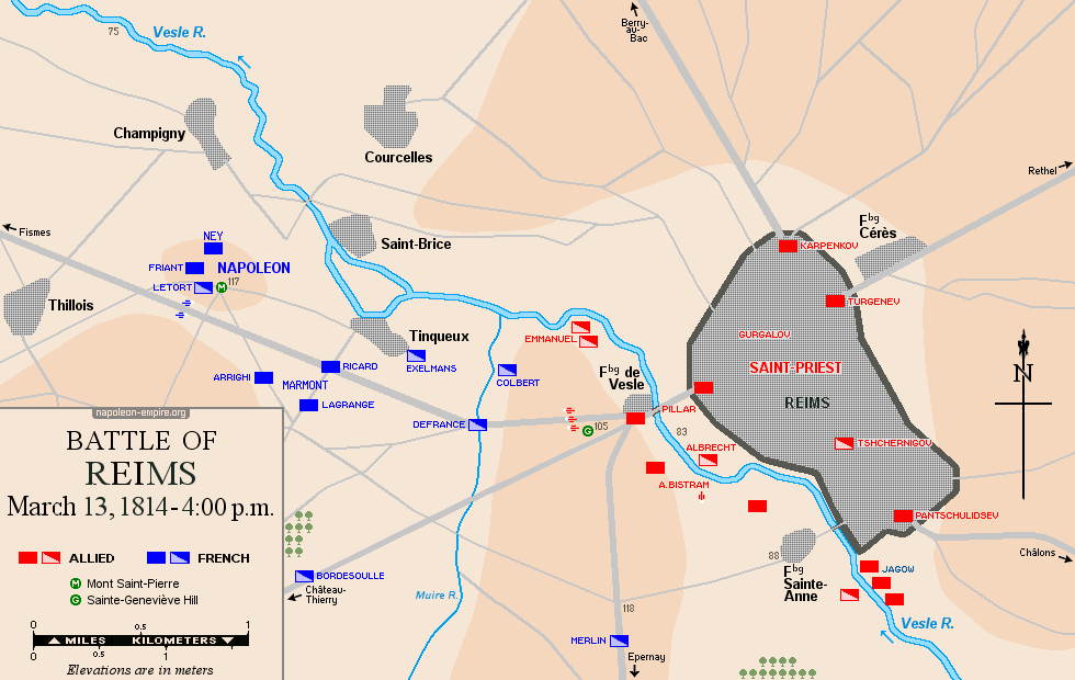
REIMS: Battle on March 13, 1814
Fierce fighting — in which "Marie-Louises" (French conscripts from the classes of 1814 and 1815) heroically took part — occurred on the left bank of the Vesle, the river that flows through the city of Saint-Remi (Reims): first near Rosnay, then on the heights of Tinqueux around Mont-Saint-Pierre, and finally in the southeastern outskirts of the city. Emperor Napoleon directed the battle from the top of Sainte-Geneviève Hill, also located in Tinqueux.
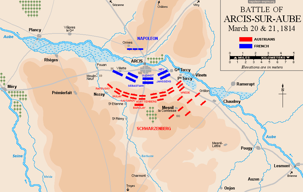
ARCIS-SUR-AUBE: Battle on March 20 and 21, 1814
The battlefield lies on the left bank of the Aube River — that is, to the south of the river. It forms a semicircle around Arcis: Villette to the west (on the road to Méry-sur-Seine), Nozay to the southwest and Mesnil-la-Comtesse to the southeast (straddling the road to Troyes), and Torcy-le-Grand and Torcy-le-Petit to the east (towards Brienne). The terrain is completely flat.
A single bridge, located in Arcis itself, provided at that time access to the right bank of the Aube. During the battle, a temporary bridge had been thrown across the river near Villette.
THE "FLIGHT OF THE EAGLE": March 1815
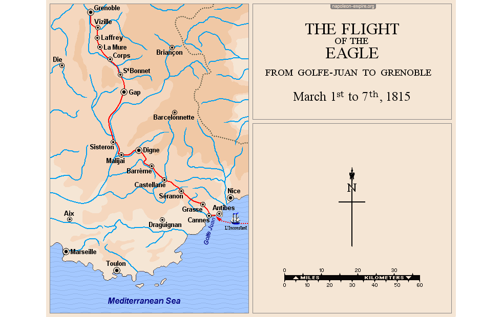
Having landed at Golfe-Juan on March 1, 1815, arriving from the island of Elba with 700 men, Napoleon led them on a legendary journey across the Southern Alps, reaching Grenoble in a week. From there, he was able to set out for Paris.
SEVENTH COALITION: 1815
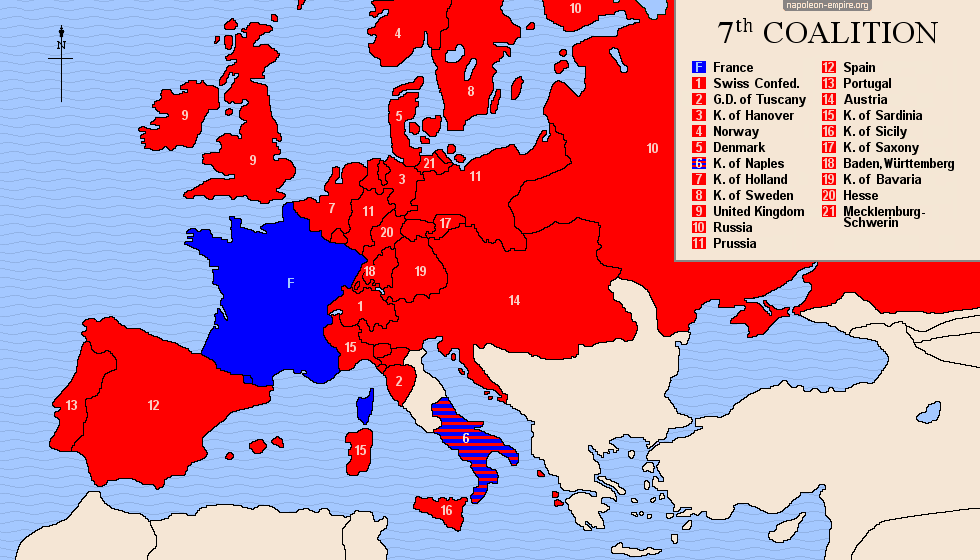
All of Europe immediately united against Napoleon Bonaparte following his escape from the island of Elba: England, Austria, Spain, Portugal, Prussia, Russia, Sweden, the Netherlands, Saxony, Bavaria, Baden, Württemberg, Hesse, Switzerland, Sicily, etc. Even the Kingdom of Naples, initially an ally of France, fell back into the orbit of the Coalition powers following Joachim Murat's defeat at Tolentino on May 2 and 3, 1815.
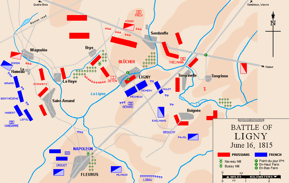
 LIGNY: Battle on June 16, 1815
The village of Ligny, in Walloon Brabant, lies about twelve kilometers (7½ miles) east of the Quatre-Bras crossroads, where Marshal Michel Ney engaged the Duke of Wellington on the same day. The battlefield — roughly triangular in shape, with its apex pointing downwards — is situated between the Nivelles-to-Namur road to the north and the town of Fleurus to the south; the terrain is moderately undulating and wooded, and is traversed by a stream with a winding course: the Ligne.
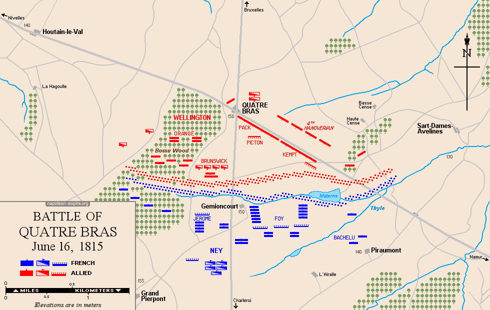
QUATRE BRAS: Battle on June 16, 1815
Quatre-Bras de Baisy-Thy is a strategic road junction in Walloon Brabant, situated at the intersection of the Nivelles–Namur road and the Brussels–Charleroi road. The fighting took place primarily on either side of the latter, south of the crossroads.
At the time, the terrain was more wooded than it is today — particularly the Bois de Bossu, which was at the heart of the fighting — and featured numerous hedgerows.
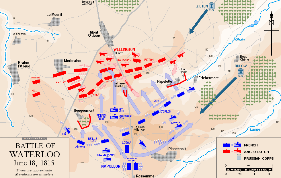
WATERLOO: Battle on June 18, 1815
The Waterloo battlefield is roughly rectangular in shape, straddling the Brussels-Charleroi north-south road axis, with Mont-Saint-Jean to the north, Papelotte and Frichermont to the east, La Belle-Alliance and Plancenoit to the south, and the outskirts of Braine-l'Alleud to the west. At the center lies the La Haie-Sainte farm, and a few hundred meters to its southwest, the Hougoumont farm.
The terrain is a succession of undulations — modest, certainly, yet significant enough to have influenced the course of the battle (troops concealed in the hollows, difficulties in moving artillery across muddy, slippery ground...)